인과순환구조 분석을 활용한 지속가능한 수변도시의 그린 인프라 도입 및 식재기반 계획 : 부산 에코델타시티를 중심으로
Abstract
Busan Eco-Delta city is being developed under the paradigm of eco-friendly waterfront cities with goals such as sustainable development, ecosystem service improvement, and climate change response, etc. To do this, it is necessary to analyze the key variables that appear in common in recognition of the planting base environment and introduction of green infrastructure and to analyze the integrated system. Therefore, the purpose of this study is to analyze the causal loop structure to construct planting base and introduce green infrastructure in realizing a sustainable waterfront city. First, the causal loop structure of the planting base environment according to tidal-flat soil, mountain soil, and dredged sediment was analyzed using system thinking in system dynamics methodology. As a result of integrating individual causal loop structures, key variables of the planting base environment were soil hardness, organic matter in soil, soil pH, soil salinity, and plants growth variables. Second, when introducing green infrastructure (urban forests, wetlands, grasslands) to the planting base, constraints were derived and presented as a causal loop structure. In urban forests, the values of soil hardness, slope, soil pH, soil salinity, soil drainage, and plant growth should be taken into consideration. In wetlands, variables of soil hardness, soil permeability, soil moisture, wetland water level fluctuation, and wetland water depth should be taken into consideration. In grasslands, consideration of the variables of soil hardness, soil drainage and permeability, soil pH, and plant growth needed. The green infrastructure introduced in this study is important in that it can respond to climate change as well as environmental pollution. It is expected that the results of this study can be used as the basis for a green infrastructure plan in the process of developing Busan Eco-Delta city.
Keywords:
Planting Base, Seashore Landfill, Green Infrastructure, Landscape Planning1. 서론
수변도시는 큰 강이나 바다, 호수 등과 접해 있는 공간에서 사람이 거주하며 항만 및 해운의 기능이나 생산활동, 또는 주거나 상업, 레크리에이션 등 인간활동이 발생하는 도시의 개념이다(Yeom, 2019). 국내에서의 수변도시는 주로 해안지역에서 대규모 워터프론트 조성사업이나 친수시설을 개발하는 위주로 이루어졌다(Jeong et al., 2011). 그러나 이러한 수변도시의 산업화 및 도시화와 함께 오염과 같은 환경문제들이 대두되게 되었고(Hong, 2011), 해수면 상승이나 강수량 증가 등 기후변화로 인한 영향이 추가적으로 나타남에 따라 그에 대한 대응의 차원에서의 계획이 수변도시를 개발함에 있어 필수적으로 요구되게 되었다(Jeon and Lee, 2015). 부산에코델타시티는 이러한 배경을 바탕으로 첨단산업 및 물류기능이 복합되어 수변레저, 문화, 생태기능이 조화된 친환경 수변도시로써 개발되었으며(Yeom, 2019), 뿐만 아니라 태풍이나 해일로 인한 침수현상으로 매년 피해가 발생하는 부산지역에서 물관리 특화기술로 홍수를 사전에 예측하고 저감할 수 있는 기후변화 대응형 도시모델을 지향하고 있다(Park, 2018).
기존에 수변도시를 계획하는 과정에서는 도시의 접근성이나 공공성, 정체성, 안전성과 같은 도시가 목표로 지향하는 속성이나 가치에 초점을 두거나(Kim et al., 2013; Lee, 2014), 지속가능성을 위한 환경관리 측면에 중점을 두었다(Kim et al., 2010). 또한 부산 에코델타시티의 경우에도 국가하천인 낙동강 주변지를 체계적이고 계획적으로 개발하여 하천중심의 미래 지향적인 수변도시로 조성하는 것을 목표로 하고 있으며, 교통체계와 지리적인 위치의 이점을 활용하여 경제의 활성화와 복합적인 문화활동, 물류와 산업 중심의 글로벌 거점도시 등 다양한 목표를 수립하고 있다(Park, 2018). 그러나 목표지향적인 계획과 개발에 선행되어야 하는 것은 식재기반과 같이 개발 이전에 수변도시의 대상이 되는 환경에 대해 분석하고, 이를 토대로 앞서 언급한 오염과 같은 환경문제나 기후변화의 영향으로 나타나는 피해에 대응할 수 있는 여건을 마련하는 것이 필요하다.
최근 수변도시를 계획하고 조성함에 있어 환경오염과 같은 문제에 대응하고 기후변화에 적응할 수 있는 방안으로 그린 인프라를 적용하는 것이 강조되고 있다(TEP, 2010; Foster, 2011). 그린인프라는 도시의 미기후 조절이나 도시열섬 저감, 대기오염 정화, 토양오염 정화, 수질오염 정화, 물순환 개선 등의 기능을 갖고 있으며 홍수를 예방하고 생태적 기능을 제공하는 등 다기능성의 효과를 갖는 녹색기반시설로 이해할 수 있다(Kang et al., 2014). 다양한 그린인프라의 유형 중에서 식재기반에 도입이 가능한 요소들을 중심으로 본 연구를 진행했다. 먼저, 도시숲과 같은 그린 인프라의 유형은 도시 내의 시민들에게 휴양이나 심리적 안정감을 제공해주는 심미적 기능뿐 아니라 생태적인 기능을 제공하고(Kong et al., 2010), 홍수조절, 산사태 방지 등 재해에 대응할 수 있는 기능뿐 아니라(Kwon, 2020) 교육 및 레크리에이션 기능들까지 다양한 생태계서비스를 제공한다. 그린 인프라의 유형으로써 습지는 육상생태계와 수생태계의 전이지대로 물이 지표면에 있거나 지표 근처에 지하수가 분포하는 공간으로 인식된다(Kim, 2015). 습지는 홍수를 조절하거나 생물의 서식처가 되기도 하며, 특히 탄소를 저감하는 탄소흡수원으로써의 기능을 하고 수질을 정화하는 환경적인 기능이 뚜렷하게 나타난다(Kim, 2003). 초지의 경우 목본이 아닌 초본으로 덮힌 토지를 뜻하며 잔디나 초화류가 서식하는 공간으로 인식된다(Ministry of Environment, 2011). 이러한 초지는 시민들에게 휴양이나 레크리에이션과 같은 기능을 도시 내에서 제공할 수 있으며 재해가 발생할 경우 대피하는 공간 등으로 활용이 된다. 따라서 이러한 그린 인프라들은 도시 내에서 생태계서비스 측면에서 다양한 기능을 제공함에 따라, 수변도시의 개발 과정에서 환경오염과 같은 문제나 기후변화로 인해 나타나는 재난재해에 대응할 수 있는 방안으로 도입되어야 한다.
2012년 사업이 구체화된 이후 개발이 진행되고 있는 최근에 이르기까지, 부산 에코델타시티를 중심으로 한 지역에서는 4대강의 이슈와 더불어 서낙동강수계를 둘러싼 수질오염 해결의 문제와 매립쓰레기 및 준설토로 인한 토양오염의 문제, 철새들의 서식환경을 위협하는 문제 등 부산 에코델타시티를 둘러싼 생태환경의 잡음들이 끊이지 않고있는 실정이다(National trust, 2013; Kim et al., 2014a; Kim et al., 2014b; Baek, 2016). 제기되고 있는 문제에 비해, 현재 수행되는 연구들은 4대강과 관련된 친수구역의 제도가 개발 행태에 미치는 영향에 대해 주민의식을 조사함으로써 개선방안을 제시하거나(Kim et al., 2014b), 비도시화 토지의 특성을 평가하여 그린 인프라를 구조적으로 적용하는 방안을 제시하고(Kim et al., 2014a) 개발사업을 위한 경관 시뮬레이션 분석을 수행하는 등(Kim, 2016) 부산 에코델타시티 사업의 타당성을 뒷받침하기 위한 연구들이 중점적으로 수행되고 있는 실정이다. 그러나 사업의 타당성이나 계획을 제시하기에 앞서 식재기반과 같은 환경을 조성하는 과정에서 공통적으로 발생할 수 있는 문제와, 그린 인프라를 도입하는 과정에서 고려해야 하는 것들을 통합적으로 분석하고 이를 계획에 활용하는 방안이 필요하다.
따라서 본 연구의 목적은 지속가능한 수변도시를 구현하는 과정에서 식재기반을 조성하고 그린 인프라를 도입하기 위한 인과순환구조를 분석하며, 이를 바탕으로 식재기반 계획을 제시하는 것이다. 이를 위해 첫째, 부산 에코델타시티를 대상으로 식재기반환경에 대한 인과순환구조를 분석한다. 둘째, 갯벌흙과 산토, 준설토에 따라 변화하는 식재기반에 대한 인과순환구조를 분석한다. 셋째, 앞서 분석된 식재기반에 그린 인프라(도시숲, 습지, 초지)를 도입하기 위한 제약사항을 분석하고 이를 바탕으로 한 식재기반계획을 제시한다. 본 연구의 결과는 부산 에코델타시티와 같은 임해매립지 환경에서 식재기반을 조성하고 그린 인프라를 도입하는 계획을 정책적으로 제시하는 과정에서 근거자료로 제시될 수 있다.
2. 연구방법
2.1. 연구대상지
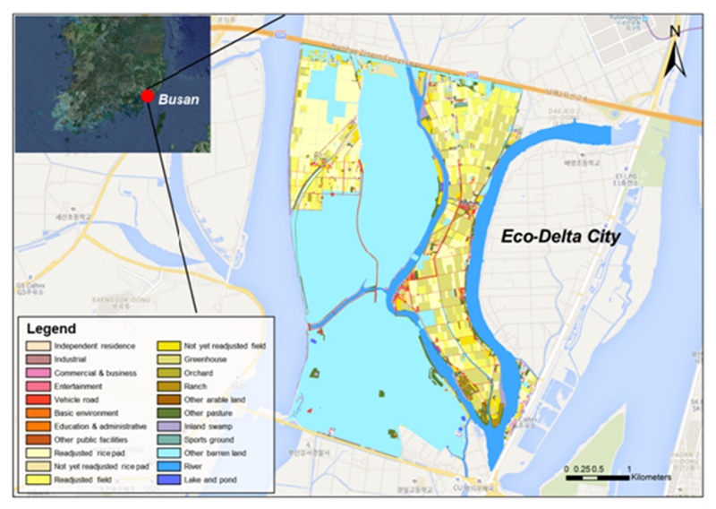
부산 낙동강 에코델타시티는 강서구 명지동, 대저 2동 일원에 11,885,910 m2 면적으로(Fig. 1) 지난 정부정책으로 추진되었던 포트비즈니스밸리 계획과 부산광역도시계획의 국제산업물류도시계획(국제산업물류도시의 2단계 계획)을 반영하여 복합물류·산업 도시를 추진 중에 있다. 에코델타시티는 2012년 6월에 친수구역으로 지정되었으며, 같은 해 7 ~ 8월 주민공람 및 설명회를 가졌고 11 ~ 12월 중앙도시계획 위원회 및 친수구역조성위원회의 심의를 거쳤다. 이후 2012년 12월 에코델타시티 내의 개발제한구역을 해제 고시(11.057 km2)하였고 친수구역으로 지정고시(11.885 km2)하였다.
대상지는 대부분이 자연녹지지역과 제1종일반주거지역으로 지정되어 있으며, 대상지 서쪽으로 서낙동강, 동쪽으로 맥도강, 대상지 내부로는 평강천이 흐르고 있다. 대상지 서쪽으로 봉화산과 금병산이 동쪽으로는 승학산과 백양산이 있어 위요된 형태의 평지이며, 남서쪽으로 을숙도 철새도래지와 맞닿아있다. 본 대상지에서는 김해공항이 확장되고, 에코델타시티 조성으로 인한 주민들 보상의 갈등, 에코델타시티의 정보화도시 계획 등 다양한 사회시스템 상의 문제가 나타나고 있다. 또한 낙동강 수계 하천의 수질오염과 토양오염, 매립쓰레기, 뉴트리아 문제, 낙동강지역 철새수감소 등 에코델타시티 조성과정에서 생태시스템 상의 환경문제들이 대두되고 있는 실정이다.
2.2. 연구방법
본 연구에서는 부산 에코델타시티의 식재기반 환경을 조성하고 그린 인프라를 도입하기 위해 시스템 사고를 기반으로 한 인과순환구조 분석을 수행했다. 시스템 사고는 다양한 인과관계를 복합적으로 파악하고 이를 바탕으로 시스템이 어떻게 작동하는지를 이해할 수 있는 사고로, 다수의 변수 간 인과관계들이 복잡하게 순환되어 있는 구조를 분석하기에 유용한 방법이라고 할 수 있다(Jung and Kim, 2007). 이러한 과정에서, 기존의 문헌이나 다양한 자료를 고찰함으로써 인과관계에 대한 근거를 마련하고 인과순환구조로 표현한다. 시스템 사고를 바탕으로 한 인과순환구조의 작성은 인과관계를 양(+)과 음(-)의 부호와 화살표를 활용하여 도식화하고, 피드백 루프는 양의 피드백과 음의 피드백으로 구분하여 극성이 양(+)일 경우 시간의 흐름에 따라 시스템이 동일한 방향으로 증가 또는 감소하며 음(-)의 경우 시스템이 목표점으로 수렴되고 안정화된다(Moon, 2007). 이러한 이론적인 근거를 바탕으로 본 연구에서는 부산 에코델타시티를 계획하기 위해 식재기반을 조성하는 과정에서 토양을 중심으로 한 환경 시스템의 인과관계들을 파악하고 이를 구조화하여 다양한 토양환경에서 공통적으로 작용하는 변수들을 핵심변수로 도출했다. 또한, 도출된 핵심변수들을 중심으로 그린 인프라를 도입하는 과정에서 나타나는 시스템의 변화와 피드백 루프에 대해 인과순환구조를 바탕으로 분석했다.
본 연구에서는 먼저부산 에코델타시티의 환경을 분석하기 위해 부산 에코델타시티와 관련된 문헌자료들을 수집했으며, 대상지역과 유사한 환경인 임해매립지에서의 식재기반관련 자료를 RISS와 Google scholar 등을 통해 수집했다. 다음으로, 식재기반 환경에 대해 토양과 관련된 변수들로 범위를 한정하여 인과관계를 도출하였으며 식재기반에 적용되는 토양의 종류(갯벌흙, 산토, 준설토)에 따라 토양환경과 식물의 생육에 미치는 시스템을 분석했다. 그 과정에서 식재기반에 적용되는 토양의 종류는 부산 에코델타시티와 같은 임해매립지의 환경에서 매립되는 토양을 기준으로 적용하고자 했다(LH, 2000). 마지막으로, 앞서 분석한 식재기반 환경을 바탕으로 부산 에코델타시티에 적용하고자 하는 그린 인프라의 유형별(도시숲, 습지, 초지)도입에따른 시스템의 변화를 분석하고자 했다.본 연구에서 활용된 그린 인프라의 유형들은 기존 수변공간이나 도시에 적용된 그린 인프라의 사례들을 바탕으로 선정되었다(K-water, 2015).
3. 연구결과 및 고찰
3.1. 부산 에코델타시티 식재기반의 인과순환구조
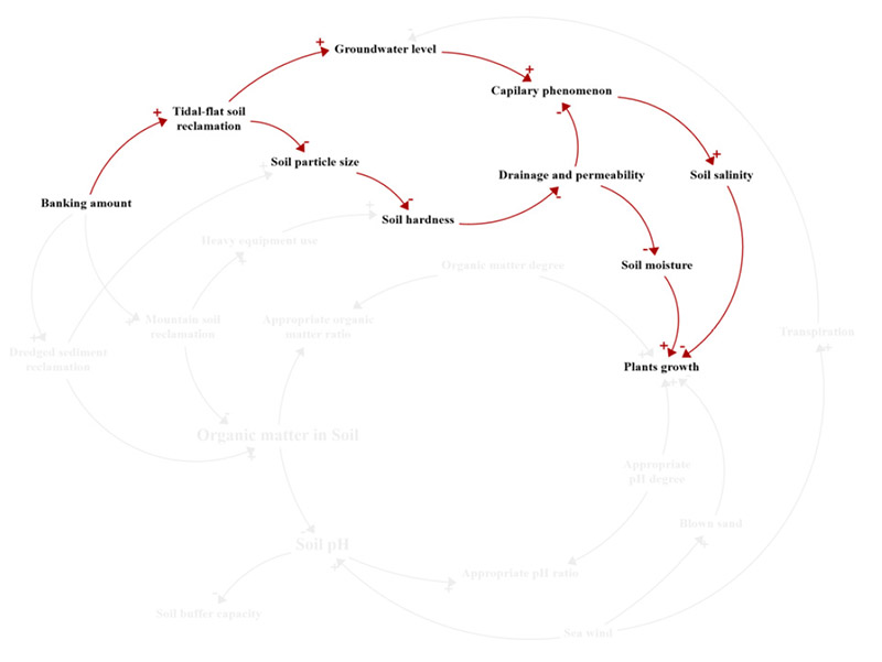
부산에코델타시티의 식재기반을 조성할 때 성토재로써 갯벌흙을 활용할 경우, 토양환경이나 식물의 생육에 미치는 영향관계를 인과순환구조로 표현했다(Fig. 2). 각 변수들 간의 인과관계에 대해서는 기존의 갯벌흙을 활용하여 임해매립지의 식재기반에 활용한 연구들을 참고하여 정리했다(Table 1). Table 1에 따르면, 갯벌흙으로 성토 시, 미사와 점토로 구성되어 입자의 크기가 커 토양경도를 증가시킴으로써 식물의 생육을 도울 수 있다. 토양경도가 높은 반면에 지하수위가 높고 토양구조가 발달하지 않아 배수 및 투수가 낮으므로 모세관 현상으로 토양의 표층부가 높은 염분 상태를 나타낸다.
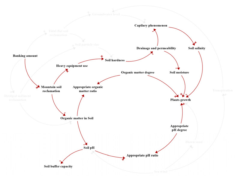
부산 에코델타시티의 식재기반을 조성할 때 성토재로써 산토를 활용할 경우, 토양환경이나 식물의 생육에 미치는 영향관계를 인과순환구조로 표현했다(Fig. 3). 각 변수들 간의 인과관계에 대해서는 기존의 산토를 활용하여 임해매립지의 식재기반에 활용한 연구들을 참고하여 정리했다(Table 2). Table 2에 나타난 바와 같이 산토로 매립할 경우, 다른 토양들에 비해 중장비에 의한 토양다짐이 많아서 토양경도가 높다. 토양경도가 토양의 염분과 식물의 생육에 미치는 영향을 고려하면 배수 및 투수는 토양의 염분을 증가시켜 식물의 생육을 저해하지만 한편으로는 토양의 수분도 증가시키므로 토양의 수분 및 염분 상태도 고려해야 한다. 산토로 매립 시에는 또한 토양의 유기물과 pH에 대한 문제도 같이 고려해야 한다.
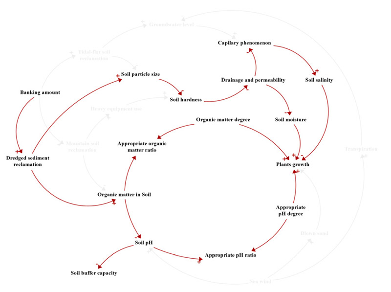
부산 에코델타시티의 식재기반을 조성할 때 성토재로써 준설토를 활용할 경우, 토양환경이나 식물의 생육에 미치는 영향관계를 인과순환구조로 표현했다(Fig. 4). 각 변수들 간의 인과관계에 대해서는 기존의 준설토를 활용하여 임해매립지의 식재기반에 활용한 연구들을 참고하여 정리했다(Table 3). Table 3에 서술한 것처럼 준설토로 매립할 경우, 초기에는 다른 토양에 비해 염분 농도가 높으나(0.15% 이상) 사질토양으로 이루어져 입자가 크고 토양의 경도가 낮으므로 탈염이 잘되어 토양 염분이 낮아지게 된다. 모세관의 염분 상승이 다른 토양에 비해 낮고 토양의 유기물 함량이 높아 식물의 생육에 긍정적인 영향을 미치게 된다. 일부 미립자가 집중된 부분은 배수와 통기가 불량하여 염분의 용탈이 쉽게 일어나지 않으므로 토양의 염분이 감소하기까지에는 많은 시간이 소요되게 된다.
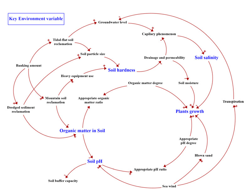
갯벌흙, 산토, 준설토로 인한 부산 에코델타시티의 환경변화 개별 인과순환구조를 통합하여 각매립재료의 활용에 따라 식재기반인 토양환경과 식물생육에 미치는 영향을 통합 인과순환구조로 분석했다. 갯벌흙으로 매립할 경우에는 토양경도의 증가로 식물의 생육을 증진시키는 한편, 지하수위의 상승올 토양의 염분이 증가하여 식물의 생육을 감소시키게 된다. 산토로 매립할 경우에는 중장비를 사용하기 때문에 토양경도가 증가하고 식물의 생육이 증진되며 토양의 유기물이 감소, pH 농도를 증진시키게 된다. 결국 적정 유기물과 pH를 벗어난 환경은 식물의 생육을 저해시키게 된다. 준설토로 매립할 경우에는 사질토양으로 인해 토양의 경도가 낮고 배수가 양호하여 탈염으로 인해 토양의 염분이 감소, 식물의 생육이 활발해진다. 반대로 배수 및 투수로 인한 토양수분의 감소는 식물의 생육을 저해시키게 된다. 갯벌흙, 산토, 준설토를 매립시키는 과정에서 공통적으로 식재기반 환경에 미치는 영향을 분석한 결과, 핵심변수는 토양경도, 토양 내 유기물, 토양 pH, 토양염분, 식물 생장등으로 나타났다(Fig. 5). 따라서 그린 인프라를 도입하는 과정에서 공통적으로 도출된 식재기반 환경의 핵심변수를 고려해야 한다.
3.2. 그린 인프라 도입의 제약사항 분석
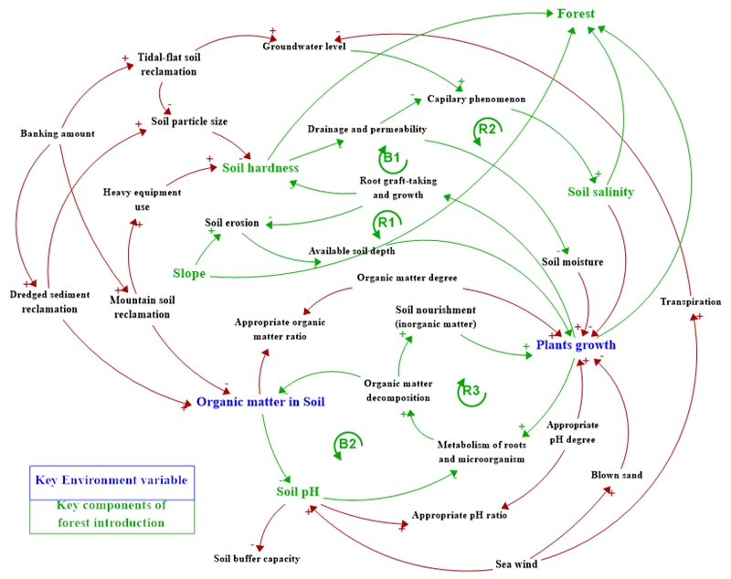
부산 에코델타시티식재기반 환경에 대한 인과순환구조를 기반으로 도시숲 도입시에 필요한 제약사항을 도출했다. 그 과정에서, 도시숲이 토양이나 식생 등 식재기반 환경에 미치는 영향에 대한 인과관계들을 도출했다(Table 4). 이를 바탕으로 구체적인 분석에 대해서는 Fig. 6에 따라 먼저, 복토 높이에 따른 토양환경변화 및 수목생장의 측면이다. 수목의 뿌리가 활착될수록 토양의 침식이 방지되어 수목의 생육에 요구되는 유효토심이 유지되고식물의 생육이 지속적으로 증가될 수 있다(R1). 또한 토양경도에 영향을 미쳐 토양염분이 지속적으로 감소되므로 식물의 생육이 증가하는 한편(R2), 배수 및 투수는 토양수분을 감소시켜 식물의 생육을 늦추기도 한다(B1). 그러나 식물의 생육으로 인한 뿔의 활착과 성장은 R1과 R2가 지배적인 구조로 작동되기 때문에 이를 고려한 도시숲 도입이 필요하다. 추가적으로, 부산 에코델타시티와 같은 임해매립지는 매립에 의한 지하수위의 상승으로 토양 염분이 증대되어 식물의 생육을 저해시킬 수 있기 때문에 이에 대한 고려도 필요하다. 둘째로 인공조림을 위한 적지 및 적수분석의 측면이다. 식물의 생육은 뿌리와 미생물의 대사가 활발하게 하여, 미생물에 의해 유기물 분해로 생성된 토양 양분이 식물의 생육을 증진시키므로(R2), 뿌리와 미생물의 대사작용에 대한 고려가 요구된다. 그 과정에서 유기물 분해로 인해 토양 내 유기물이 감소하여 토양의 pH가 높아질 위험이 있으므로(B2), 적정 pH에 대한 농도를 고려하는 것이 도시숲의 도입 과정에서 필요하다. 이러한 내용을 바탕으로 도시숲 도입에 따른 인과순환구조를 나타낸 그림은 다음 Fig. 6과 같다.
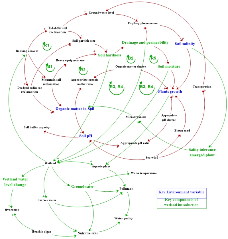
부산 에코델타시티 식재기반환경에 대한 인과순환구조를 기반으로 도출된 유형 중에 습지 도입시에 필요한 제약사항을 도출한다. 그 과정에서, 도시숲이 토양이나 식생 등 식재기반 환경에 미치는 영향에 대한 인과관계들을 도출했다(Table 5). Table 5에 나타낸 내용을 기반으로 정리하면 첫째로, 수환경 조성기법의 측면이다. 담수지, 기수지, 염생습지 등에서 수환경을 조성하기 위해서 지표수, 지하수를 이용해야 한다. 해수나 담수 지표수를 이용하는 경우 영양염류와 오염물질이 함께 증가하기 때문에 물의 수질에 대한 고려도 필요한 부분이다. 담수나 기수지조성시 지하수를 이용할 경우, 지표수보다 적은 오염물질로 수질정화에는 효과적이나 영양염류가 부족하다는 단점이 존재한다. 또한 지하수는 지표수보다 수온이 낮으므로 여름철에 수온을 저감시킨다. 다양한 수심은 수생식물의 중요한 환경이며 수위변동이 심하게 일어나게 되면 각종 수생생물의 서식에 악영향을 줄 수 있다. 또한 일반적으로 유속이 빠른 경우보다는 느린 경우가 수생생물의 다양성 유지에 좋으나, 일부 빠른 유속을 가진 공간도 생물다양성에 기여하므로 고려해야 한다. 둘째로 토양환경 조성기법의 측면이다. 이는 지표수의 침투력과 관련을 갖고 있으며, 침투력이 낮으면 강우에 의해 지표수가 일시적으로 습지 내로 유입되어 불리한 환경을 만들 가능성이 있다. 그에 대한 토양의 조건은, 정수식물 생육부가 부식질이 많고 부드러우며, 투수, 통기, 배수성이 양호하다. 또한 토양의 pH가 중성에 가까우며 질소, 인산 등 필요성분은 포함하고 유해물질은 함유하지 않아야 한다. 셋째로, 친환경적 호안 조성의 측면이다. 식물에 의한 오염물질의 흡수, 분해 기능을 위해 식생 여과대를 조성함으로써 수질의 생물학적 정화기능을 극대화하는 것이다. 마지막으로, 습지의 복원 및 조성을 위한 식재설계기법 측면이다. 식재지반은 배수성, 투수성, 유효수분, 유효토층, 토양경도 등 물리적 요건들을 고려해야 하며 양이온 치환용량, 토양산도(pH), 전기전도도 등의 화학적 요건들뿐 아니라 미생물, 토양동물 등의 생물학적 요건들도 고려해야 한다. 자생 식생 복원의 개념은 식생천이 발달을 관리하고 극상 군집으로의 발달을 가속화하는 것이 주된 요소이다. 특히 습지의 경우는, 도시숲이나 초지와 달리 지표수, 지하수, 수생식물을 활용하는 측면에서 식재기반의 성토량을 저감시킬 수 있는 효과가 있는 그린 인프라로써 갯벌흙, 산토에 의한 토양경도를 낮추는 역할을 하고(R1, R2), 배수 및 투수를 높이며(R3, R4) 그에 따라 토양수분을 낮춰(B3, B4) 습지의 조성에 영향을 미칠 수 있다. 또한 준설토에 의한 토양경도를 높이고(B1),배수 및 투수를 저감시켜(B2) 토양수분을 높임에 따라(R5) 습지의 조성에 영향을 미치기도 한다.따라서 습지를 도입하고자 하는 경우에는 성토의 변화에 따른 토양의 변화를 고려할 필요가 있으며, 이는 다음 그림 Fig. 7과 같다.
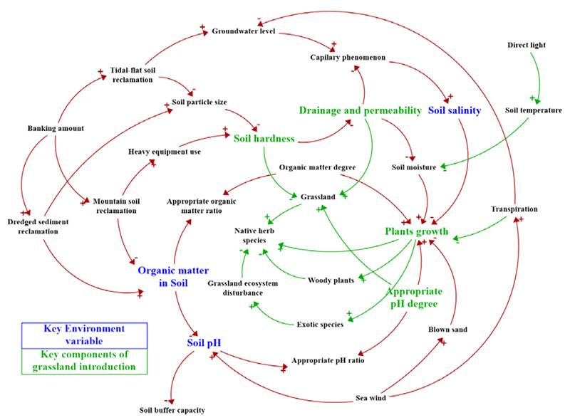
부산 에코델타시티 환경에 대한 인과순환구조를 기반으로 도출된 유형 중에 초지 도입시에 필요한 제약사항을 도출한다. 그 과정에서, 도시숲이 토양이나 식생 등 식재기반 환경에 미치는 영향에 대한 인과관계들을 도출했다(Table 6). Table 6에서 나타난 내용을 서술하면 초지생태계를 복원할 경우 검토사항은 먼저, 식물천이 단계에서 관목, 교목 등 목본류의 침입이 용이하므로 그에 대한 관리가 필요하다. 또한 식물천이 단계에서 외래종에 의한 교란이 우려되므로 관리가 필요하다. 초지의 하고현상(고온으로 인한 식물의 생육 저해, 한발현상으로 인한 식물의 스트레스, 고온과 한발에 강한 잡초의 침입, 여름철 습도의 상승으로 인한 병해충의 발생)으로 초지생태계의 생육이 저해되므로 그에 대한 관리가 필요하다. 이러한 내용을 바탕으로 도시숲 도입에 따른 인과순환구조를 나타낸 그림은 Fig. 8과 같다.
그린 인프라별로 핵심요소의 제약사항은 다음과 같다. 도시숲의 경우 토양 경도, 경사도, 토양 pH, 토양 염분, 토양배수 및 식생의 생육에 대해 검토가 필요하다. 습지 계획 시에는 토양 경도와 토양의 투수능력, 토양의 수분(유효수분), 습지의 수위 및 수심에 대한 검토가 필요하다. 초지를 계획하는 과정에서는 토양 경도와 배수 및 투수, 적정 pH의 농도, 식물의 생육(하고현상)에 대한 검토가 필요하다.
도시숲의 경우 구체적인 식재기반 계획은 다음과 같다. 토양 경도의 측면에서 도시숲을 조성하기 위한 식재기반인 토양의 경도가 수목의 뿌리 신장과도 밀접한 관계가 있기 때문에 18 ~ 20 mm 전후일 때는 세근의 발달이 용이하나, 24 ~ 25 mm일 때에는 심한 저해를 받으며, 29 mm 이상일 때는 뿌리가 전혀 자라지 못한다. 일반적으로 모래와 점토가 적당한 비율(점토함량 10 ~ 20%, 모래함량 50 ~ 70%)로 혼합된 사양토가 수목의 생육에 가장 적합하다. 경사도의 측면에서 도시숲을 조성하기 위한 수목 식재가 가장 용이한 경사도는 5° 이하인 평탄지가 적절하다. 경사도가 높은 지형인 산과 구릉지의 경우 토양 침식이 일어나 유효토심이 낮고 건조한 지역일 가능성이 높기 때문이다. 토양 pH의 농도는 수종마다 다르지만, 보통은 pH 5.5 ~ 6.5가 적절하다. 토양 산도가 임계점(pH 4.5)보다 낮아지면 토양 내 미생물의 대사 작용이 멈추어 토양 생태계가 붕괴되므로, 식재 계획된 수목의 선호 pH 환경을 조성하고 임계점(pH 4.5) 이하로 떨어지게 관리하는 것이 중요하다. 토양 염분의 경우 0.05% 이하로 유지하는 것이 바람직하다. 토양 염분이 높아지면 토양의 삼투압 농도가 상승하여, 수목의 수분 흡수를 억제시키고 그로 인한 지엽의 탈수 현상이 일어나 광합성량 감소로 수목의 생육을 저해시킨다. 토양 배수 및 식생의 생육 측면에서, 저지대 수변도시는 토양의 배수가 느린 Sandy Loam이 주 성분을 이루고 있기 때문에 다양한 식생의 생육에 제약조건이 있다. 따라서 개발 후에도 강우의 집중과 분산, 흡수 등을 유도할 수 있는 저영향개발 기법(LID)의 도입이 적극적으로 고려되어야 하며, 시설, 배수지, 범람지에서도 생육이 가능한 식물종에 대한 적극적 연구와 도입이 고려될 필요가 있다.
습지의 식재기반 계획은 다음과 같다. 토양 경도의 측면에서 습지를 조성하기 위한 식재기반 토양은 20 mm 이하로 하는 것이 바람직하며 30 mm 이상인 경우에는 식물의 생육이 곤란하다. 또한 토양 투수의 경우 습지를 조성하기 위해 요구되는 토양의 포화투수계수는 10-3cm/s가 적당하며, 10-3 ~ 10-4 cm/s에서도 생육은 가능하며, 10-4 cm/s 이하에서는 건전한 생육에 지장이 있으므로 투수성을 높여줄 필요가 있음. 또한 10-5 cm/s 이하인 경우에는 식물의 생육이 불량하다. 습지 조성 시 토양의 유효수분은 체적비로 120 l/m3이면 양호하고 120 ~ 80 l/m3이면 적정, 80 ~ 40 l/m3이면 개량을 요하며 40 l/m3 이하이면 식물의 생육에 지장을 초래하기도 한다. 습지 수위변동에서는 변동치가 약 30 cm/일인 경우에는 큰 영향이 없으나, 90 cm/일인 경우에 수생생물의 다양성에 나쁜 영향을 미치게 된다. 습지 조성 시 다양한 수생생물의 서식을 위해서는 다양한 수심을 제공해주어야 하는데, 곤충의 유충에 적합한 깊이는 50 cm 이상이며 작은 물고기가 서식할 수 있는 정도의 깊이는 최소 45 cm 정도이다. 겨울철의 동결 및 여름철의 증발량을 고려하면 최대수심을 1 m 이상 유지해야 한다.
초지의 식재기반 계획은 다음과 같다. 토양 경도의 측면에서 초지를 조성하기 위한 식재기반 토양은 20 mm 이하로 토양경도를 하는 것이 바람직하며 30 mm 이상의 경우에는 식물의 생육이 곤란하다. 배수 및 투수의 측면에서 초지를 조성하기 위해서 토양의 포화투수계수는 10-3 cm/s가 적당하며, 10-3 ~ 10-4 cm/s에서도 생육은 가능하며, 10-4 cm/s 이하에서는 건전한 생육에 지장이 있으므로 투수성을 높여줄 필요가 있음. 10-5 cm/s 이하인 경우에는 식물의 생육이 불량하다. 한여름 고온조건하에서 초지식생의 생육이 멈추고 수면상태로 들어가는 하고현상은 높은 기온이 오래 지속될수록 피해가 커지는데, 고온과 한발에 의한 생육장해가 가장 크며 두 요인의 복합작용으로 발생한다. 하고기간 중 예취높이에 따른 초지식생 고사율, 잡초발생율, 지표온도, 하고지수 등을 분석해보면 예취높이가 3, 6, 9 cm로 높아짐에 따라 초지식생 고사율은 47.9%, 27.6%, 16.8%로 감소했으며 잡초 발생율 역시 27%, 16%, 9.1%로 감소했다. 지표면 온도는 33.7℃, 31.8℃, 30.7℃로 감소했으며 하고지수도 2.09, 1.55, 1.23으로 감소하여(Seo, 1985) 하고기간 중 높은 예취높이는 하고에 대한 스트레스를 크게 저감시킬 수 있을 것으로 판단된다. 그에 대한 종합 조건을 정리하면 Table 7과 같다.
앞서 그린 인프라를 통합 식재기반 계획에서 도출된 제약사항에 따라 그린 인프라가 도입된 수변도시는, 다양한 생태계서비스 측면에서의 혜택을 기대할 수 있다. 특히 기후변화의 측면에서 도시숲의 경우 탄소 흡수 및 저장의 기능을 통해 대기의 CO2를 제거하거나, 도시 내 냉난방 에너지 사용 저감을 통해 온실가스 배출 감축을 실현시키고 바이오매스 에너지로 활용됨으로써 기후변화에 대응할 수 있다(Korea Forest Research Institute, 2012). 습지의 경우 탄소흡수원으로써의 기능을 할 뿐 아니라, 수변에 위치한 습지는 홍수와 같은 자연재해로 인한 피해를 완화해주는 완충지대로써의 역할을 수행하여 기후변화에 대응할 수 있다(Jung, 2010). 초지역시 그린 인프라로써 토양 침식이나 홍수 방지, 산불 확산의 억제 등 기후변화로 인해 나타나는 문제에 대응할 수 있는 기능을 수행할 수 있다(Kang, 2012). 다만 그 과정에서 추가적으로 고려해야 할 사항은 기후변화에 대한 대응 측면에서의 그린 인프라 기능뿐 아니라,도입 과정에서 기후변화의 영향으로 변화하는 식재기반 환경이다. 초지의 하고현상이나 도시숲과 습지에서의 식물 생육과 같은 요소들은 기후변화의 영향으로 향후 조건이 변할 수 있기 때문에, 향후 그린 인프라를 실질적으로 계획하는 과정에서는 기후변화의 영향에 대한 부분까지 고려할 필요가 있다.
4. 결론
본 연구는 부산 에코델타시티를 대상으로 시스템 사고를 활용하여 식재기반 환경의 변화를 분석하고 그린 인프라를 도입하기 위한 인과순환구조를 분석하고자 했다. 이를 위해 먼저, 부산 에코델타시티를 대상으로 식재기반 환경에 대해 토양 중심으로 인식하고 그에 대한 인과순환구조를 도출하고자 했다. 그 과정에서 갯벌흙이나 산토, 준설토와 같은 토양의 종류에 따라 변화하는 식재기반 환경을 분석하고 통합 인과지도를 통해 공통적으로 도출되는 핵심 환경변수를 제시하고자 했다. 마지막으로, 도입 가능한 그린 인프라(도시숲, 습지, 초지)에 따른 제약사항을 도출하고 이를 기반으로 부산 에코델타시티의 식재기반계획을 제시하고자 했다. 본 연구의 결과는 부산 에코델타시티와 같이 수변도시를 개발하는 과정에서 식재기반계획을 수립하는 근거로 제시할 수 있다.본 연구를 바탕으로 도입되는 그린 인프라는 수변도시를 개발하며 나타나는 환경오염의 문제뿐 아니라 기후변화로 인한 환경의 변화에 대응할 수 있는 방안으로 제시할 수 있다.특히 기후변화의 측면에서 도시숲과 습지, 초지와 같은 그린 인프라는 홍수와 같은 자연재해에 대응하고, 도시 내에서 다양한 방식으로 탄소를 흡수하거나 열섬현상을 저감시킬 수 있기 때문에 기후변화에 효과적으로 적응할 수 있을 것으로 기대한다. 뿐만 아니라, 4대강을 포함한 다양한 이슈로 변화하는 수질이나 생태 등의 환경의 자연적인 회복에도 영향을 줄 수 있을 것으로 판단된다.
본 연구에서는 시스템 사고를 통한 인과순환구조를 분석하는 과정에 있어서 문헌고찰을 통해 구조를 구성하고 관계나 내용을 분석했으므로, 추후 연구에서는 본 연구에서 분석한 시스템의 구조를 기반으로 관련 변수들에 대한 구체적인 데이터를 수집한 뒤, 이를 시뮬레이션 모델링을 통해 환경의 변화를 수치적으로 예측하고자 한다. 이를 통해 수변도시를 개발하는 과정이나, 현재 부산 에코델타시티의 개발 과정에서 그린 인프라를 도입하는 계획을 제시할 경우 과학적이고 타당한 근거로 제시될 수 있을 것을 기대한다.
Acknowledgments
이 논문은 고려대학교 오정리질리언스연구원(OJERI)의 지원을 받아 수행되었으며, 2017년 대한민국 교육부와 한국연재단의 지원을 받아 수행된 연구임(NRF - 2017S1A5A2A03068778).
References
- Baek KH. 2016. Eco-Delta City success, water quality improvement is a priority. BDI Policy focus 2016(2): 1-12.
- Cho U. 2000. A Study on the Development of Green Land Creation Technique in Coastal Landfill in Incheon. The Incheon Institute Repot.
- Choi IH, Hwang KH. 2000. A case study on planting environment and improvement in the reclaimed seaside areas. Land & Housing Institute Repot.
- Choi KH, Choi G, Kim Y. 2014.Salty wind damages in windbreak forests of Jeju Island by typhoon Bolaven. Journal of the Korean Geographical Society 49(1): 18-31.
- Choi NH. 2015. A Study on the Components and Systems Archytypes of the Resilience for the New Regional Development Strategy. Journal of Korean System Dynamics Society 16(4): 155-178.
- Foster J, Lowe A, Winkelman S. 2011. The Value of Green Infrastructure for Urban Climate Adaptation. The Center for Clean Air Policy.
- Jeon H. 2015. Study on the Direction of Domestic Waterfront Urban Planning Corresponding with Climate Change – Focusing on Sihwa Waterfront – [dissertation]. Incheon University.
-
Jeon H, Lee KJ. 2015. A Direction of Urban Planning on the Waterfront for Public through Corresponding with Climate Change - A Case Study on the Design Competition in New York and Boston -. Journal of the Architectural Institute of Korea Planning & Design 31(11): 39-50.
[https://doi.org/10.5659/JAIK_PD.2015.31.11.39]

- Jeong GS, Kim Y, Seo IJ. 2011. Comparative Analysis of Urban Regeneration Case Cities through Waterfront Regeneration. Journal of The Korean Urban Management Association 24(4): 267-298.
- Jung JC, Ju S, Lee JW, Lee JJ. 2002. Fate and Activity of Microorganism introduced into the Soil. Journal of Korea Organic Resource Recycling Association 10(2): 100-116.
- Jung JU, Kim HS. 2007. A Study on Ensuring Validity and Increasing Power of Expression on Causal Maps. Journal of Korean System Dynamics Society 8(1): 97-115.
- Jung SM. 2010. Sustainable coexistence of wetlands and humans in the era of climate change. Wetlands and Life 4(2): 3-4.
- Kang JE. 2012. Green Infrastructure Strategy for Urban Climate Adaptation. Korea Environment Institute report.
-
Kang JE, Lee MJ, Koo YS, Cho YH. 2014. Development and Application of Green Infrastructure Planning Framework for Improving Urban Water Cycle: Focused on Yeonje-Gu and Nam-Gu in Busan, Korea. Journal of Environmental Policy 13(3): 43-73.
[https://doi.org/10.17330/joep.13.3.201409.43]

- Kim DA. 1969. Methods and Problems of Grassland Construction. local administration 18(188): 28-34.
- Kim DH, Mun TH, Kim D. 1999. System Dynamics. Seoul: Daeyoung.
-
Kim DH, Seo HJ, Lee BK. 2014a. Method of Green Infrastructure Application for Sustainable Land Use of Non-urban Area: The Case Study of Eco-Delta City. Journal of Korea Society of Environmental Engineers 36(6): 402-411.
[https://doi.org/10.4491/KSEE.2014.36.6.402]

- Kim DY, Lee SH, Lim SJ. 2011. Analysis of the Effect of Tree Roots on Soil Reinforcement Considering Its Spatial Distribution. The Korea Society For Environmental Restoration and Revegetation Technology 14(4): 41-54.
- KimG. 2003. Wetlands and Environment. Seoul: Academybook.
- KimGH, Jeong WH. 2006.Monitoring and Analysis of Nutrients in Sediments and Surface Water in the Downstream of the Geum River. Korean Society on Water Environment proceedings. P1175-1180.
- Kim JC. 2008. Planting Plan and Function Arrangement of Large Green Space Constructed in Seashore Reclaimed Land - A Case Study of Shiwha Multi-Techno-Valley Development Area – [dissertation]. The University of Seoul.
-
Kim JG, Kim YJ, Kang YW, Hong JS. 2014b. The Effect of the Special Law on the Waterfront-Space Use on Space and Landscape Change of Four Major Rivers – Focused on the Eco Delta City Project of Nakdong River -. Journal of the Korean Society of Civil Engineers 34(2): 699-710.
[https://doi.org/10.12652/Ksce.2014.34.2.0699]

-
Kim HJ. 2012. Current Status and Environment-Friendly Development Policy of Urban Riverfront in Korea on the Basis of It’s Locational Property. Journal of the Korea Contents Association 12(3): 449-460.
[https://doi.org/10.5392/JKCA.2012.12.03.449]

- Kim SY. 2007. Waterfront Development and Urban Regeneration. Urban Problem 42(465): 23-31.
-
Kim YJ, Kang YW, Hong JS, Kim JG. 2016. Landscape Changes Simulation of the Riverfront using a Multipoint Multiple Sight Surface Method and Elevation Blockage Ratio – Focused on Eco Delta City Project of Nakdong River -. Journal of Korea Planning Association 51(2): 93-109.
[https://doi.org/10.17208/jkpa.2016.04.51.2.93]

- Koo BH, Kang JS, Chang KS. 1999. A study of soil characteristics in coastal reclaimed areas for planting ground treatment. Korean Journal of Environment and Ecology 13(1): 89-95.
- Korea Forest Research Institute. 2012. Urban Forest as Carbon Protector. Korea Forest Research Institute Report.
- Korea Forest Service. 2000. Forest & Forestry Technique. Daejeon: Korea Forest Service.
- Korea Forest Service. 2007. Urban Forest Construction Management Manual. Daejeon: Korea Forest Service.
- LH. 2013. Establishment of planting design plan for waterfront reclaimed land to overcome the limitations of the ecological environment. LH Repot.
- Ministry of Environment. 2011. A Study on the Systematic Restoration of Damaged Natural Environment. Ministry of Environment Report.
- Ministry of Oceans and Fisheries. 2003. Replacement wetland creation mid- to long-term plan establishment service. Ministry of Oceans and Fisheries Report.
- Moon TH. 2007. Sustainable City with System Thinking. Paju: Jipmoondang.
- Hong SU. 2011. Towards ‘Green Bank City’ Design: General Principles, International Examples and Korean Applications [dissertation]. Inha University.
-
Hong YJ. 2013. Analysis of Spatial Characteristics and Internal Structure of Waterfront in Incheon. Journal of the association of Korean geographers 2(2): 165-182.
[https://doi.org/10.25202/JAKG.2.2.4]

- Seo S. 1985. The haze phenomenon of grasses and grassland management in summer. Dairy & Beef Farmers. 43(-): 27-30.
-
Song K, You S, Chon J. 2018. Simulation modeling for a resilience improvement plan for natural disasters in a coastal area. Environmental Pollution 242(-): 1970-1980.
[https://doi.org/10.1016/j.envpol.2018.07.057]

-
Song K, Chon J, Choi NH. 2021. Ecosystem Services Analysis and Resilience Improvement Planning in Nakdong River Area using Systems Thinking. Journal of Korean System Dynamics Society 22(2): 33-43.
[https://doi.org/10.32588/ksds.22.2.2]

- Song KW. 2013. Eco-Delta City, a world-class waterside ecological city - Creation of an eco-friendly and water-friendly international industrial logistics city with global competitiveness. Busan Development Forum –(140): 40-51.
- TEP. 2008. Toward a green infrastructure framework for Greater Manchester.

